Sandy, with rocky sections, and debris common after rain or swell. On-street along the Galisbay waterfront. Availability depends on the time of day and on port activity. Treat it as town parking rather than beach parking. Drive-up access. No fee.
Getting in
Roadside, no walk
Parking
Street parking. On-street along the Galisbay waterfront, with availability depending on the time of day and on port activity, though generally easier than at small residential beaches. Nobody publishes a count. This is the best-served beach on the French side for public transport, simply because it is in town: Marigot is the hub for shared minibuses and the Anguilla ferry runs from the port here, so anyone already in Marigot walks.
Water
Calm
Shorebreak
Calm
Snorkeling
Not worth it
Food on site
Nothing on site
Facilities
No chairs and umbrellas, restrooms, snacks and drinks, showers, natural shade, or lifeguard
On a ship day
Low
Crowds
Moderate
Best time
Sunset, walked from Marigot. The tourist office is right about that much: the colours over the bay toward Anguilla are the reason to be here.
Best for
Sunset or a long walk
Safety
Assume there is no lifeguard, because the sources disagree and that is the safe direction: the Saint-Martin tourist office describes a marked swim zone and lifeguard-monitored areas, while an independent guide states there is no lifeguard and that swimming depends on shoreline conditions, weather and port activity. This is a working commercial harbour, so boat traffic is the constant hazard and parts of the shoreline are port estate rather than beach. French Wikipedia's entry on the area lists oil pollution risk from the EDF power plant and the commercial port, potential groundwater contamination, coral reef degradation in the bay and cyclone flood risk. Nobody publishes bathing water quality results for this beach, and for a beach next to a cargo port and a power station that is the gap that matters most. Stay inside any marked zone and well clear of vessel movements.
The story
Galisbay is Marigot's own beach, and it is also the island's cargo gateway. The Établissement Portuaire de Saint-Martin runs the commercial port, the ferry terminal for Anguilla, moorings and some cruise traffic from an address given as Baie de la Potence, Galisbay. So the honest description is a shoreline that is simultaneously the town's everyday beach and the place the island's freight arrives. That is unusual and interesting, and it is a better page than either the beautiful-secluded-beach version or the not-a-real-beach version. Both of those are lazy.
Checked: August 2026 · Reported
Is it actually a swimming beach? Sources disagree
This is the central question about Galisbay and the published record contradicts itself.
The Saint-Martin tourist office describes an active local swimming beach with a line marking out a swim zone and lifeguard-monitored areas, used daily by residents of Marigot, Concordia and Agrément doing morning exercise, families holding celebrations, and children's camps during school holidays. It also lists barbecue areas, fishing spots and sound equipment for events.
An independent guide is much more cautious: swimming depends heavily on shoreline conditions, weather and activity around the port, some areas have rocks, seaweed or unclear water, there is no lifeguard, and visitors should check the sea before entering, stay close to shore and avoid swimming near boat traffic. It concludes the beach works best as a passing stop, walk and photo spot combined with a Marigot visit. The same source says there are no uniform beach facilities on the sand.
Both sources have obvious biases: the tourist office promotes, the guide site hedges. The most defensible synthesis is that this is a genuine local swimming beach with municipal swim-zone marking, sitting next to a commercial port, with conditions and water quality that vary. That makes it a real beach for residents and a poor use of a visitor's limited beach days.
Somebody standing on this sand can settle the lifeguard question in one minute by looking for a swim-zone line and a lifeguard post. Until then, we assume none.
Baie de la Potence from the Fort Louis walls in December 2011. Potence means gallows, and it is the name the port still uses for this bay.Richie Diesterheft · Wikimedia Commons · CC BY-SA 2.0
A 140 to 150 million euro port expansion is on the table
The Galisbay-Bienvenue extension project would deepen the channel to nine metres to take vessels up to 200 metres long, extend the quay, and grow the terminal from three hectares to between six and ten, at an estimated 140 to 150 million euros.
The stated goals are quadrupling container traffic over a decade, rebalancing freight flows between Sint Maarten and Saint Martin, securing island autonomy on supply, and keeping port access open during severe weather.
The process is documented: a preliminary public consultation closed in May 2024, the appointed guarantors published their assessment on 4 September 2024, and the project moved to continuous consultation status that same month.
This is the most consequential thing happening on this stretch of coast and virtually no English-language beach content mentions it. What we will not do is overstate it. Continuous consultation is not construction, and we could not establish a build start date or whether the beach itself falls inside the footprint. That is exactly the question to put to the Établissement Portuaire.
The name is about a gallows, and the lagoon behind it is 95% gone
French Wikipedia records that Galisbay is a corruption of the English Gallow bay, after gallows where executed prisoners were displayed. The bay is still officially called Baie de la Potence in port addressing, which is the same name in French.
It also documents something more consequential. This area was largely lagoon fringed with mangrove before the 1986 tax incentive law, and today only about 5% of its pre-1980 surface remains, the lagoon having been deliberately filled and then built on. The natural lagoon had worked as a sediment filter during heavy rain, and its loss is linked to cyclone flood risk, oil pollution exposure from the power plant and the port, groundwater contamination potential and coral reef degradation in the bay.
Galisbay today holds a municipal sports complex, the commercial port, EDF power stations including a 2003 diesel unit, a desalination plant and assorted commercial premises.
That is one of the clearest documented cases on this island of a tax-driven development law reshaping a coastline, and it is a genuine history and environment story rather than a beach story. It rests on French Wikipedia, which is well constructed here but is still a tertiary source, so the 5% figure in particular wants chasing to its primary reference before anyone leans on it.
A wreck in the bay in December 2011. Hulls come and go here, so this particular one is very likely long gone: read it as atmosphere rather than as something you will find.Richie Diesterheft · Wikimedia Commons · CC BY-SA 2.0
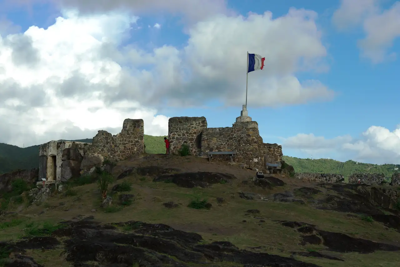
Fort Louis is above you, and it is the reason to come
Fort Louis sits on the hill between Marigot and Galisbay, free to enter. The climb is 89 steps, with parking available partway up, and about 30 minutes covers the ascent and a look around. The views take in Marigot, Simpson Bay and Anguilla. What remains is largely ruins, some cannons and interpretive plaques, with railings on the stair, iguanas on the ground and no shade to speak of, so bring water and go early or late.
The Marigot market operates below daily, with expanded activity on Wednesdays and Saturdays. The tourist office counts seven lolos near the ferry terminal, naming Bruno's Place, Chez Coco and Rosemary's, though we did not independently verify that any of them is currently trading.
Here is the editorial call. Galisbay is not worth a beach day on its own. Fort Louis plus the market plus a sunset walk along the Galisbay waterfront is a genuinely good half day. If you want a French-side beach day within 15 minutes, go to Friar's Bay or Baie Rouge instead.
Getting here is easy: this is Marigot's own shoreline, running north from the town's small lighthouse toward Grand Case, walkable from the town centre and roughly 15 to 20 minutes from the airport via Cole Bay and Sandy Ground.
Common questions
Quick fact
Is Galisbay actually a swimming beach?
Sources disagree. The tourist office describes an active local swimming beach with a marked swim zone and lifeguard-monitored areas. An independent guide says swimming depends on conditions and port activity, that rocks and debris are common, and that there is no lifeguard. Locals do swim here, but it is a town beach beside a working cargo port.
Quick fact
What is Port de Galisbay?
It is Saint-Martin's commercial port, run by the Établissement Portuaire de Saint-Martin, handling cargo, the Anguilla ferry from the maritime station, moorings and some cruise traffic, at Baie de la Potence, Galisbay. A 140 to 150 million euro extension has been through preliminary public consultation.
Quick fact
How do you get to Fort Louis from Galisbay?
Fort Louis is on the hill above Marigot and Galisbay. Entry is free, there are 89 steps, parking is available partway up, and about 30 minutes covers the climb and a look around. Bring water and go early or late, since there is very little shade.
Quick fact
Where does the name Galisbay come from?
It is an English-to-French corruption of Gallow bay, after gallows where executed prisoners were displayed. The bay is still officially called Baie de la Potence, which means the same thing in French, in the port's own addressing.
Quick fact
Should I spend a beach day at Galisbay?
No. Pair it with Marigot instead: the market, Fort Louis, and a sunset walk along the waterfront. If you want a French-side beach day within 15 minutes, go to Friar's Bay or Baie Rouge.
Last checked August 17, 2026. Everything on this page is confidence reported: drawn from credible sources but not independently confirmed by us. Beach conditions change with the weather and the season, and businesses on the sand open and close, so check anything you are building a day around.
Desk research pass, docs/research/research-galisbay.md, holding the full claim to source table and the confidence flag on every claim
Ships in port, what's on, and island conditions for the week ahead. Every Monday. A couple of minutes to read, unsubscribe anytime.
Something went wrong on our end and we could not add you just now. Please try again in a moment, or emailleslie@thisissxm.comand we will add you by hand.
We will only use your email for island guide updates. Unsubscribe anytime.


.jpg)
.jpg)