Skip to content
This Is SXM

One people · One island · One destiny

Live now
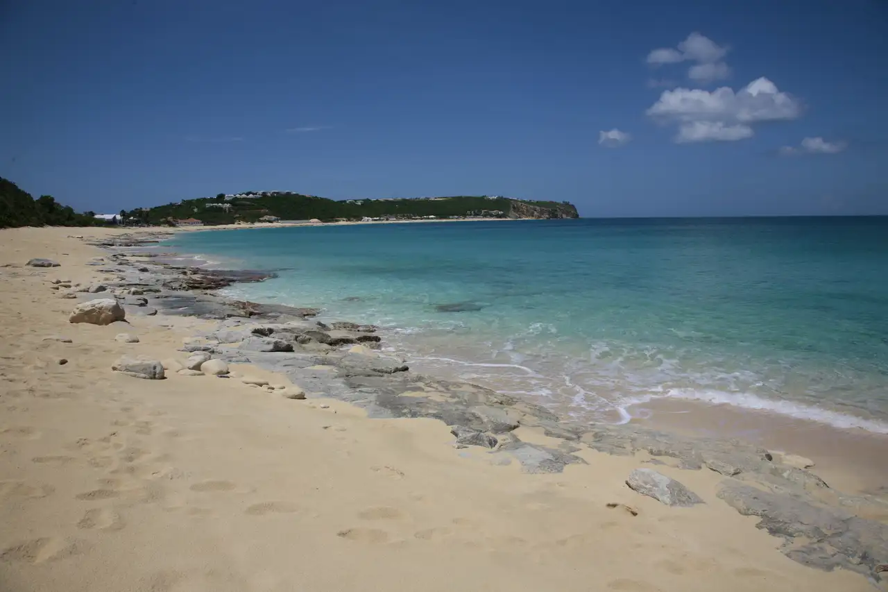
The reddish-gold sand of Baie Rouge running below low ochre cliffs, with clear water along the shoreline

Baie Rouge

Baie Rouge

French side
  • Secluded
  • Sunset
  • Snorkeling

Fine, with a pink to reddish-gold cast. A free dirt lot at the east end holding roughly 50 cars, reached down a short access road with a gate. The surface is badly potholed. Short walk in. No fee.

Getting in
Steps down
Parking
Free lot. Roughly 50 cars on dirt at the east end, and the surface is the thing people warn about. A September 2025 visitor wrote that these are not potholes, they are sinkholes, and pull in slowly. A March 2026 visitor said the lot has not improved since they first came in 2012. Free, unattended, and no theft reports surfaced, though nobody is watching it. There is a gate on the short access road off the main Lowlands road; reports across a decade agree it does not stop members of the public, and Baie Rouge is the designated public access for this stretch of coast.
Water
Varies
Shorebreak
Strong
Snorkeling
Fair
Shade
No shade
Chairs
No chair rental
Food on site
Nothing on site
Restrooms
None
Facilities
No chairs and umbrellas, restrooms, snacks and drinks, showers, natural shade, or lifeguard
On a ship day
Low
Crowds
Quiet
Best time
The hour before sunset, when the cliffs throw their warmest light and the local crowd turns up
Best for
Sunset, quiet, or snorkeling
Safety
This is one of the few beaches on the island where the shorebreak is written down by an eyewitness rather than inferred. A February 2025 visitor described a wave that takes you back into the sea quickly, rocks hidden in it and swept along by it, a steep slope, and the wave running high up the beach. That is a textbook steep-face dumping shorebreak with strong backwash, on a beach with no lifeguard and loose rock moving in the swash. Strong currents are reported as well. At the Trou de David entry point specifically, expect sharp rock and sea urchins, and do not enter the submerged or semi-submerged cliff caves without specific training. Watch several waves before anyone gets in, and keep small children out of the shorebreak entirely.

The story

Baie Rouge is 1,400 metres of pinkish sand under ochre cliffs on the Terres Basses, facing northwest toward Anguilla, with a swimmable rock arch at the east end and absolutely nothing else. No bar, no chairs, no toilets, no shade you did not bring. There were two beach bars here for decades and half the internet still lists them as open. There is also a 4,000-year-old archaeological site under the parking lot, which is part of why the bars could never be made legal.

Checked: August 2026 · Reported

The beach bars are gone, and almost every guide still says otherwise

Gus' Beach Bar and Grill and Chez Raymond ran on Baie Rouge for decades. Guides still list them. Google Maps still shows them. Villa rental sites still promise you grilled fish and steel drums at the weekend. All of it is out of date, and here is what actually happened.

Both bars sat on land the Terres Basses owners' association considered private, in a non-buildable zone under the local planning rules, on top of a protected archaeological site, without any authorisation of temporary occupation from the association. French authorities shut them down periodically for years before 2017; one forum account describes both bars closed and their chairs and tables confiscated well before the hurricane.

Gus' survived Irma physically in September 2017 but was removed afterwards and never reopened, because post-Irma rules required permits even to rebuild an existing structure near the water. Chez Raymond was closed on 21 August 2018 by order of the prosecutor, on findings that the operators occupied private property without right or title, had built without permits in a non-buildable zone, employed undeclared staff and sold alcohol without a licence. It was then demolished. The owners' association said the prosecutor had required the demolition and that access would be free and the beach would stay free and natural. Louis Mussington, then in opposition and now President of the Collectivité, objected that the building was torn down before any final judgment.

Visitors in 2023, 2025 and 2026 all confirm there is still nothing there. Pack a cooler and water, and do not trust a map pin on this beach.

A small wooden beach bar shack standing at the edge of the sand at Baie Rouge
Gus' Beach Bar in January 2015. It survived Irma physically in 2017, was removed afterwards and never reopened. There is nothing here now.Paul SablemanWikimedia CommonsCC BY 2.0

There is a 4,000-year-old settlement under the parking lot

Baie Rouge holds one of the most significant archaeological sites in the northern Lesser Antilles, and it sits directly under the beach access.

INRAP, the French national preventive archaeology institute, records that the site was found in 2003 during geotechnical surveys for a planned residential development, and that it is the first stratified preceramic site recognised in the archipelago. A radiocarbon date from an intermediate layer gave 3490 plus or minus 40 years before present, which calibrates to roughly 1910 to 1700 BC. The 2004 excavation covered more than 500 square metres and found shell middens, hearths and flaked stone tools. A separate operation mapped the site and laid a protective backfill over it, so it was deliberately covered to preserve it.

One French travel account, less reliably, describes a second and much later occupation, around 1100 AD and again around 1500 AD, potentially contemporary with Columbus's 1493 passage, and gives a different discovery date entirely. That does not reconcile with INRAP's account. It may be two sites in the same bay, or two layers, or the blog may simply be wrong, and we are not going to pick a version. What is not in dispute is that a protected site is one of the reasons the beach bars could never be regularised.

The arch is at the east end, not the west

Guides are vague about where Baie Rouge's rock arch is, and it often gets described as being at the far or western end. It is at the east, the same side as the parking.

Three independent sources agree. A March 2026 visitor swam around the rocks on the right side as you face the water and reached an adjacent bay with a small sand beach and a natural arch. A villa guide places the cave on the right side of the beach, reachable at low tide. And Les Fruits de Mer, the St. Martin natural history association, places the Trou de David snorkel site between Baie Rouge and Pointe du Bluff, which is the eastern headland. French Wikipedia lists the pocket beach beyond the arch as a beach in its own right, Plage de l'arche, 70 metres long, reachable only by sea, with an explicit warning about changes in swell.

Trou de David is a separate and larger feature: a natural hole roughly 80 feet across with two arches leading in from the sea, where you can swim in through the larger left-hand one. You reach it either by a dirt road off the junction of the Baie Rouge road and the main Lowlands road, or by a long snorkel from the beach. The entry is over sharp rock with many sea urchins, and Les Fruits de Mer warns against entering the caves without specific training.

Snorkeling generally here is calm days only, around the rocky point at the east end. Quality is going the wrong way: an April 2026 visitor reported that the reef to the right is almost entirely dead, with limited fish variety. Baie Rouge sits outside the Réserve Naturelle, so there is no protected status, no enforcement and no monitoring data for this bay at all.

A small second beach at the end of Baie Rouge with dark openings worn into the rock behind it
The second beach and its grottos at the east end, photographed in December 2011. This is the stretch you swim around the rocks to reach.Richie DiesterheftWikimedia CommonsCC BY-SA 2.0

Why the sand looks red, and why the answer is a bit boring

The tourist board says the sand takes on a reddish tone at sunset, which makes it a lighting effect and gives the beach its name. Other sources attribute it to the warm reddish tone of the sand and the cliffs themselves. A third calls it simply fine pinkish sand.

The common factor in all of them is the ochre-red cliffs backing the bay, which both colour the sand as they erode into it and throw warm light across it late in the day. Both mechanisms are real, and there is no need to pick one.

What matters if you are planning: the beach is genuinely most red in the hour before sunset, which is also when it is busiest with local residents. Turn up at noon expecting red sand and you will be disappointed. That expectation-setting is more useful than another paragraph about the colour.

Getting here: about 10 to 15 minutes from Marigot through Sandy Ground and Baie Nettlé onto the Terres Basses road, or 35 to 45 minutes from Philipsburg up the Dutch side through Maho and Cupecoy and across into the Lowlands. There is no public transport into Terres Basses at all and no practical way in without a car. The beach sits about 150 metres from the main road, and there are steps down from the parking to the sand, which the Association Wall Art St. Martin has decorated. Steps plus deep sand plus a rutted lot means this is not a beach for limited mobility.

Rocks at the edge of Baie Rouge silhouetted against a low orange sunset over the water
Sunset at Baie Rouge in December 2009. This is the hour the sand actually reads red, and the hour the beach fills up.Upsilon Andromedae (upsand)FlickrCC BY 2.0

Common questions

Quick fact

Is there a beach bar or restaurant at Baie Rouge?

No. Gus' and Chez Raymond both closed after Hurricane Irma and a 2018 prosecutor's order, and Chez Raymond was demolished. Nothing has replaced them, and visitors from 2023 through 2026 confirm no snack bar, no chair rental and no toilets. Guides and map listings showing a restaurant here are out of date.

Quick fact

Where is the rock arch at Baie Rouge and can I swim to it?

It is at the east end, the same end as the parking lot. Swim or wade around the rocks on the right as you face the water and you reach a small adjacent beach with the arch. Do it only on a calm day: French Wikipedia flags the pocket beach beyond it with an explicit warning about changes in swell.

Quick fact

Is Baie Rouge safe for swimming?

Only on calm days, and never assume. Visitors describe a steep beach face, a shorebreak that runs high up the sand and pulls you back out, and loose rocks moving in the waves. Strong currents are reported too, and there is no lifeguard. Watch a few waves before anyone gets in.

Quick fact

Do I need to pass a security gate to get to Baie Rouge?

There is a gate on the short access road off the main Lowlands road, and visitors consistently report getting through without difficulty. The beach is public and Baie Rouge is the designated public access for this stretch of coast. The bigger obstacle is the parking lot, which is badly potholed.

Quick fact

Does sargassum affect Baie Rouge?

Rarely. Sargassum comes ashore on the Atlantic-facing east and southeast coasts. Baie Rouge faces northwest toward Anguilla on the sheltered side of the island. A March 2026 visitor confirmed no trace of it.


Keep planning

Where this fits


Sources

Where this comes from

Last checked August 17, 2026. Everything on this page is confidence reported: drawn from credible sources but not independently confirmed by us. Beach conditions change with the weather and the season, and businesses on the sand open and close, so check anything you are building a day around.

Stay posted

Get the week ahead on SXM

Ships in port, what's on, and island conditions for the week ahead. Every Monday. A couple of minutes to read, unsubscribe anytime.