A long ribbon of light, soft sand. Free street parking along the roads behind the beach, plus complimentary parking at beachfront restaurants for their customers. There is no dedicated public beach lot. Drive-up access. No fee.
Getting in
Roadside, no walk
Parking
Street parking. Free street parking behind the beach and restaurant parking for customers, with no dedicated public lot. No break-in reports for this beach turned up in local news during research, which is not the same as none happening. The two real constraints on getting here are the Simpson Bay bridge, which stops road traffic completely each time it opens for yacht traffic, and Airport Road congestion at arrival and departure peaks. Between them they are why 20 minutes from Philipsburg can become 45.
Water
Varies
Snorkeling
Not worth it
Shade
No shade
Chairs
Chairs available
Food on site
Beach bar
Restrooms
Customers only
Facilities
Chairs and umbrellas, snacks and drinks. No restrooms, showers, natural shade, or lifeguard
On a ship day
Low
Crowds
Moderate
Best time
Late afternoon into sunset. The length absorbs people, so it rarely feels busy away from the bars at either end.
Best for
Families, a long walk, sunset, or quiet
Safety
No lifeguard, and no published incident record for this beach. The two published characterisations of the water conflict: the tourism board sells calm and family friendly, and a local aggregator says the sea gets deep quickly. Both are consistent with the geography, since the bay faces southwest and is calm in the prevailing easterly trades but exposed when wind or swell swings south or west. The entry gradient is not uniform over two and a half kilometres, so read the water where you actually get in rather than trusting a blanket claim. The western mile borders the Princess Juliana runway, with the noise and jet blast that implies. From April to December this is an active sea turtle nesting beach: stay 15 metres from turtles and hatchlings, keep off marked areas, and do not drive on the sand or push umbrellas into a nest. The Office of Disaster Management names Simpson Bay Beach among the island's flood-prone and erosion-exposed areas.
The story
Simpson Bay Beach is the long one. Two and a half to three kilometres of sand running southwest from the Pelican Key headland out to the end of the airport runway, with bars at either end and mostly quiet residential frontage in between. It is where people walk dogs, where turtles nest, and where the Nature Foundation recorded the cleanest tested water on the Dutch side, a few hundred metres along the same shoreline from the dirtiest. It is also the one beach in this part of the island that does not change character when four ships are in port.
Checked: August 2026 · Reported
Where this beach actually is, and where Kim Sha stops
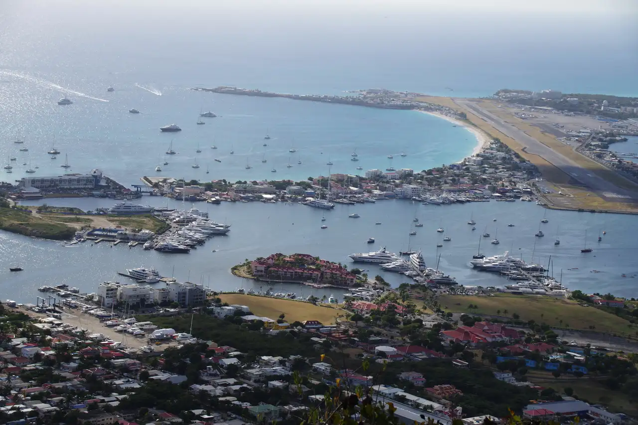
Simpson Bay is the wide, southwest-facing bay between the Pelican Key headland in the east and the airport in the west. The eastern end, at the base of the Billy Folly hill, is called Kim Sha Beach. Simpson Bay Beach, in local usage, means everything west of roughly the Atrium Beach Resort, running past the Royal Palm and Karakter, along the Simpson Bay Village waterfront, and out to Mary's Boon and the runway.
The practical rule: Kim Sha is the short, busy, bar-lined east corner. Simpson Bay Beach is the long, quieter, mostly residential stretch west of it. Same sand, different day, and as the water quality section shows, measurably different water.
Total length is not published anywhere credible. The tourism board calls it one of the longest beaches on the island and says it borders the runway for about a mile at the western end, without giving a total. Working from gazetteer anchors, the shoreline runs roughly 2.5 to 3 km. That is derived, not sourced, and somebody should measure it.
Facilities are thin, and that is a real difference from Great Bay. The tourism board states plainly that there are no public showers directly on the beach and that K's Beach Club's showers are for its guests only. Plan on using a restaurant.
The sand at Simpson Bay in December 2011. The beach runs far enough that this is one small piece of it.Richie Diesterheft · Wikimedia Commons · CC BY-SA 2.0
The cleanest tested water on the Dutch side, next door to the dirtiest
The Nature Foundation's water quality report of 29 October 2020 sampled four Dutch-side beaches against the US EPA safe-swimming threshold of 35 colony-forming units of Enterococci per 100 ml.
Simpson Bay Beach came in lowest, at an overall average of 5.4 CFU. Kim Sha Beach, the same continuous shoreline a few hundred metres east, averaged 136.7 CFU, roughly four times the threshold, with one section recorded as too numerous to count, and the report recommended that Kim Sha not be used for swimming until the situation improved. Mullet Bay and Cupecoy came in below the threshold on average with individual sections above it. Simpson Bay and Kim Sha were both sampled between 24 and 26 March 2020.
The story is not that Simpson Bay is clean. It is that a few hundred metres of shoreline separates the best and worst results on the island, that the report attributes the problem to wastewater discharge from nearby businesses and the Simpson Bay Lagoon, and that no retest has been published in more than five years.
So the number on this page is a March 2020 result. It is the most recent one that exists.
Turtles nest here, and people walk dogs here
In early June 2022 the Nature Foundation confirmed nesting activity by a leatherback on Simpson Bay Beach, with reports of activity near Karakter Beach Bar. Nesting season on Sint Maarten runs April to December. This is also where the Foundation relocated a 150-egg green sea turtle nest from Great Bay in October 2018, because Great Bay's umbrellas and tourism activity threatened it and Guana Bay, the usual relocation site, was choked with sargassum. In the Foundation's 2019 nesting record, Simpson Bay is one of only five beaches on the island with recorded nests.
The Foundation's guidance is specific: stay at least 15 metres from turtles or hatchlings, avoid marked nesting areas, keep pets away, avoid flash and bright lights, and report sightings on +1 (721) 544-4267 or WhatsApp +1 (721) 581-6365. Its warning about the sand itself is blunt: driving on, walking over, placing beach chairs or piercing umbrellas into the area of the eggs can cause severe damage to the whole nest.
And this is the island's dog-walking beach. The tourism board says so directly. Those two facts sit uncomfortably together from April to December, and saying so is more useful than pretending they do not.
Declared an environmental disaster, swimmable again in under three weeks
Simpson Bay was declared an environmental disaster on 2 October 2017, in the weeks after Hurricane Irma. After cleanup by the Nature Foundation, parts of the beach were declared safe for swimming in less than three weeks, along with Mullet Bay, Cupecoy, Maho and Dawn Beach in front of what was then the Westin. Great Bay still needed more work at that point. Swimmers were warned about sharp objects and exposed rocks.
That is a specific, dated recovery story, and most beach pages on this island do not have one.
The bay behind the beach has its own history. The tourism board's account is that Simpson Bay was historically part of a continuous sandbar with the airport area, and that a storm in 1819 created the gap connecting the lagoon to the Caribbean near Pelican. The first wooden bridge over it went up in 1933, replaced by a stone and cement bridge in 1950. A canal was cut in 1970, and the excavated sand created Snoopy Island, now used for superyacht docking. The current bridge replaced a swivel bridge in 1989.
The village is said to be named after Captain John Simpson, credited with defeating two pirate frigates nearby in the 17th century, and to have developed as a fishing community with Scandinavian roots. Label the Captain Simpson story and the Scandinavian origins as local tradition: neither is sourced beyond tourism copy. The 1819 storm and the bridge dates are specific enough to be checkable in the archives, and worth confirming.
Simpson Bay in October 2014, days after Hurricane Gonzalo passed. The photographer noted the bay was empty of boats because of the storm, so this is not a typical day.alljengi · Wikimedia Commons · CC BY-SA 2.0
The airport end, and the bars
The western mile of this beach borders the Princess Juliana runway. Maho, on the other side of the runway threshold, gets all the attention for the landings. The Simpson Bay side is where aircraft depart from, and where the beach is quiet. If you want the aviation experience without the Maho crowd, that is the trade. What jet blast conditions are actually like at this end, and whether there is any safety signage, we do not know and would want checked before anyone plans around it.
Named by the tourism board as on or beside the beach: D's Beach Bar & Grill, K's Beach Club, Boon's, Balls & Wine, Al Pasha, Beirut and the Lotus nightclub. Karakter Beach Bar is independently confirmed through a 2022 Nature Foundation turtle report, and Mary's Boon sits at the western end near the runway. On the wider strip behind: Pineapple Pete's, The Hideaway, Juliette's Bistro, Topper's Rhum Distillery, Bovin Steak House, Replay Sports Bar and Huppel The Pub. Prices are in US dollars.
One honest caveat on that list: only Karakter is confirmed by dated 2025 or 2026 reporting. The rest come from an undated tourism board page, so check anything you are building an evening around.
This is the island's main nightlife strip, so the beach has an evening life the quieter Dutch-side beaches do not. It is also roughly 25 minutes by taxi from the cruise pier and is not a standard walk-off destination, which is why it is the answer in this part of the island for a beach that does not change when the ships come in.
Common questions
Quick fact
How long is Simpson Bay Beach?
Nobody publishes a reliable figure. The tourism board calls it one of the longest on the island and says it borders the airport runway for about a mile at its western end. Working from gazetteer coordinates, the shoreline runs roughly 2.5 to 3 km from the Pelican Key headland to the runway.
Quick fact
Is Simpson Bay Beach the same as Kim Sha Beach?
They are the same continuous shoreline. Kim Sha is the short eastern corner at the base of the Billy Folly hill; Simpson Bay Beach is the long stretch west of it. The distinction matters: in 2020 testing, Kim Sha had the worst bacterial counts of four beaches tested and Simpson Bay the best.
Quick fact
Is the water clean at Simpson Bay Beach?
The most recent published testing, from March 2020, put Simpson Bay Beach at 5.4 colony-forming units of Enterococci per 100 ml, well under the 35 CFU safe-swimming threshold and the lowest of four Dutch-side beaches tested. That result is now five years old and no retest has been published.
Quick fact
Can you bring a dog to Simpson Bay Beach?
Yes, it is one of the island's popular dog-walking beaches. From April to December it is also an active sea turtle nesting beach, and the Nature Foundation asks that pets be kept away from turtles, hatchlings and marked nests.
Quick fact
Are there showers and restrooms at Simpson Bay Beach?
Not public ones. The tourism board states there are no public showers directly on the beach, and K's Beach Club's showers are for its guests only. Plan to use a restaurant.
Quick fact
Does Simpson Bay Beach get sargassum?
Rarely. It faces southwest and is sheltered from the Atlantic swell that pushes sargassum onto the island's east coast beaches. Even in a heavy season like the one forecast for 2026, the west and south coasts are the clear side.
Last checked August 17, 2026. Everything on this page is confidence reported: drawn from credible sources but not independently confirmed by us. Beach conditions change with the weather and the season, and businesses on the sand open and close, so check anything you are building a day around.
Desk research pass, docs/research/research-simpson-bay-beach.md, holding the full claim to source table and the confidence flag on every claim
Ships in port, what's on, and island conditions for the week ahead. Every Monday. A couple of minutes to read, unsubscribe anytime.
Something went wrong on our end and we could not add you just now. Please try again in a moment, or emailleslie@thisissxm.comand we will add you by hand.
We will only use your email for island guide updates. Unsubscribe anytime.


.jpg)
.jpg)